
Researchers at the University of Adelaide's Unmanned Research Aircraft Facility (URAF) are working on a code of best practice for government agencies and researchers when using drones to monitor wildlife.
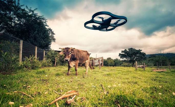
The work comes as interest grows in the potential use of drones in agriculture and conservation, both among farmers and in government departments overseeing the sector.
Interest in the field is set to accelerate after the Civil Aviation Safety Authority amended legislation allowing landowners to carry out “commercial-like” operations on their own land without needing an operator’s licence in some circumstances.
URAF has conducted joint research with the SA Department of Primary Industries and Regions on dingo fence monitoring, and the SA Department of Environment, Water and Natural Resources on fuel load mapping.
URAF researcher Jarrod Hodgson told iTnews while drones were increasingly being used to monitor animal populations, it was important to make sure potential impacts on wildlife were taken into account.
“In situations where that’s advantageous, I think that’s where we’ll see a lot of businesses and government departments taking up the use of drones,” Hodgson said.
“We think there needs to be a code of best practice for drone use around wildlife and we’re taking steps towards that at the moment.
“The code of conduct is something the whole community will need to work together to achieve. But it’s important for UAV operations to meet local regulations, through to adopting practices that are least disturbing to animals.”
To lay the foundations for a code of best practice, URAF will undertake research aimed at quantifying the levels of disturbance in order to figure out which types of flying are the least disturbing and how to minimise the impact of drones.
“Disturbance is a risk we don’t understand well yet, and so we’re doing a lot of work in that space, because we think the disturbance will vary for different species, in different environments,” Hodgson said.
“We believe it also varies based on depending on what sort of drone you’re using and what flight parameters you’re using.
“It’s even down to your flight characteristics; how high you’re flying, the style of flying and amount of movement above the animals."
Precision monitoring
The research follows the publication of a research paper by Hodgson earlier this year that showed counting birds digitally using images captured from drones was far more precise than the traditional method of ground counts.
Hodgson noted the research was largely conducted using open source technology.
“There’s a big UAV online community and a lot of forum communities, like DIY Drones, that users from recreational to commercial, share knowledge on," he said.
“Right through to software that’s used, like Mission Planner, that’s used to run the actual drone flying missions. That’s open source software and it's continually being updated and improved.”

.jpg&h=140&w=231&c=1&s=0)
.jpg&h=140&w=231&c=1&s=0)


.png&w=100&c=1&s=0)


 SAP NOW AI Tour ANZ
 Forrester's AI Forum Sydney
 The 2026 iAwards
.jpg&w=120&c=1&s=0) Integrate 2026
Integrate 2026
 Security Exhibition & Conference


_(1).jpg&h=140&w=231&c=1&s=0)


