Western Australian researchers have found a way to make different satellite positioning systems work together, with Australian firms primed to gain first-mover advantage.
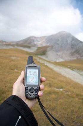
The concept has already been tested in at least one open pit mine, and could also have applications in everything from mine subsidence monitoring and atmospheric sounding to overcoming reception issues caused by "urban canyons" in cities.
The research, by Professor Peter Teunissen and Dr Dennis Odijk of the Western Australian School of Mines at Curtin University, found a way to account for the technical variation between satellite positioning systems, paving the way to use satellites from two or more systems together to resolve a positioning request.
Though GPS is the best-known satellite positioning system, it is soon to be joined by a number of other options. These include Europe's Galileo, China's Compass/BeiDou, Japan's Quasi-Zenith Satellite System (QZSS) and a regional system in India.
"The number of [global navigation] satellites will increase dramatically in the coming years, from about 75 now to about 100 in 2015 [and] to nearly 150 in 2020," Professor Teunissen told iTnews.
"The good news is - if you could combine all of those satellites, you will be able to increase accuracy but also the integrity, continuity and availability [of positioning applications]."
Technology differences
One of the keys to harnessing the collective power of otherwise separate satellite systems is to find a way to bridge technological differences in the way each has been set-up and built.
"If you mix signals from different satellite navigation systems, all sorts of inter-system [and] inter-signal biases appear," Professor Teunissen said.
The biases are the result of the varying set-up of each system and its components (satellites, hardware, measurement circumstances, etc).
The researchers in Western Australia have used "high-grade multi-GNSS" [global navigation satellite system] receivers to examine "the behaviour of inter-system biases" between the GPS and Galileo networks.
"The bad news is those inter-system biases unfortunately do not turn out to be zero — they are real," Professor Teunissen said.
"But the good news is that we found under certain mild circumstances, the dynamic behaviour of those inter-system biases is such that they change only very little over time, so that means ... one would be able to calibrate them.
"[If] you ... have a calibrated value of such an inter-system bias, you can treat it as if it is a known value."
Professor Teunissen said this opened the possibility of being able to call on various combinations of satellites for a single purpose.
For example, a geolocation request could be fulfilled by three GPS satellites and one Galileo satellite, where the latter acts, for all intents and purposes to the end user, "as if it is an additional GPS satellite".
Single receiver
Professor Teunissen said the long-term goal would be to have a single hardware receiver capable of working with multiple satellite "constellations".
"In the ideal case, it's preferred that the user doesn't even see that the systems are different," he said.
The research, which is part of a long-term body of work, is focused on "modelling and algorithmic" development rather than the manufacture of new hardware. It is intended that hardware partners may "take it further" in future.
Read on to learn about how Australia's mining industry might benefit from the research...
Mine applications
Professor Teunissen indicated the concept had already been tested at an undisclosed open pit mine, using a combination of Compass/BeiDou, GPS and Galileo satellite signals.
The researchers found they were able to manoeuvre around the blocking impact of the mine's walls to improve the ability to perform positioning from within the pit.
Miners like Rio Tinto that are turning to driverless truck systems also increasingly rely on GPS technology to define and map the courses on which the vehicles move.
Being able to take advantage of more than one satellite system may not only increase the accuracy of such driverless truck movements, but also the "integrity and reliability" of the automated systems, Professor Teunissen noted.
"The redundancy in your signals increases a lot, meaning that you can have self checking systems," he said.
GNSS hotspot
By chance, Australia is well-positioned to take advantage of the ability to mix different satellite systems, Professor Teunissen said.
"We are really well located in order to take early advantage of these developments, both from a research point of view but later on also from an applications point of view," he said.
"We actually have a sort of GNSS hotspot which is going to be created here in the Asia Pacific region [almost] on top of Singapore.
"The BeiDou system, which ultimately is going to be a global system, is being developed in phases. The second stage is a regional system, and that regional system is servicing China, but because the orbits are in a figure eight type of shape, half of that is lying over Australia.
"Japan is developing its regional system, QZSS — we are taking advantage of that. And the same for the Indian system."


.jpg&h=140&w=231&c=1&s=0)


 iTnews State of Data & AI Breakfast
 Forrester's AI Forum Sydney
 The 2026 iAwards
.jpg&w=120&c=1&s=0) Integrate 2026
Integrate 2026
 Security Exhibition & Conference


_(1).jpg&h=140&w=231&c=1&s=0)