
Europe will today launch the first of six satellites forming part of the multi-billion dollar Copernicus Earth observation project that could offer valuable images in the event of a natural disaster or even a plane crash.
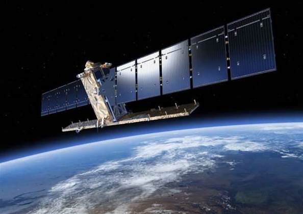
The Sentinel-1 satellite, to be sent into Earth's orbit from Europe's spaceport in French Guiana, will be used to monitor sea ice, oil spills and land use and to respond to emergencies such as floods and earthquakes.
The satellite, which carries a 12-metre-long radar antenna and has two 10 metre-long solar panels, was to lift off at 2102 GMT on Thursday night (8:20am Friday EST) aboard a Souyuz rocket and then orbit the planet at 693 km above the earth.
The Copernicus project, for which the European Union and the European Space Agency (ESA) have committed funding of around €8.4 billion (A$12.5 billion) until 2020, is described by the ESA as the most ambitious earth observation program to date.
Copernicus - which comprises six Sentinel satellite missions - is designed to supply data that can help policymakers develop environmental legislation or react to emergencies such as natural disasters or humanitarian crises.
Its launch became especially urgent after Europe lost contact with its Earth observation satellite Envisat in 2012 after 10 years.
"The big step forward is that we can now cover every place on Earth every 3-6 days," Volker Liebig, director of ESA's Earth Observation program, said.
"This used to take much longer with Envisat. If you want to use images for disaster management support or to find a plane, then you want the images to be as fresh as possible."
However, he cautioned you would first need to know roughly where a plane had crashed, which is not the case with the missing Malaysian Airlines jet.
Copernicus also offers new business opportunities.
Images can be downloaded free of charge, meaning companies can then use them to help deliver data to farmers on soil moisture or pest infestation, help oil companies decide where to drill new wells or make it easier for insurers to assess the risk of costly floods and fires.
Sentinel-1a, which will operate in tandem with a second satellite to be launched next year, Sentinel-1b, has high-tech instruments that will allow it to record radar images of Earth's surface, even when the skies are cloudy or dark.
"When there is a disaster, this means maps can be put together quickly. For instance when there are floods, other satellites often can't do the job because it's still raining and there are clouds in the sky," Liebig said.
Copernicus is one of the EU's two flagship space programmes along with satellite-navigation initiative Galileo, which is meant to rival the dominant U.S. Global Positioning System, or GPS, Russia's GLONASS and China's new Beidou system.
The main suppliers for the first Sentinel are Thales Alenia Space, Italy, for the satellite and Airbus Defence and Space, Germany, for the radar.
.jpg&h=140&w=231&c=1&s=0)
1.jpg&h=140&w=231&c=1&s=0)


.png&w=100&c=1&s=0)


 SAP NOW AI Tour ANZ
 Forrester's AI Forum Sydney
 The 2026 iAwards
.jpg&w=120&c=1&s=0) Integrate 2026
Integrate 2026
 Security Exhibition & Conference


_(1).jpg&h=140&w=231&c=1&s=0)


