
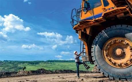
The Western Australian government is offering up 130 years worth of geological exploration data to attract mineral exploration to the state, as it competes to retain a dominant slice of the nation’s mining revenue.
This week, mines and petroleum minister Bill Marmion launched a new version of the state’s digital bedrock geology map, which underpins the publicly accessible GeoView mapping application.
As the mining boom slows down, Australia’s states continue to fight to attract new exploration across their borders.
“This map comes at a crucial time, when our resource industry needs all the help it can get to maintain momentum and find the mines and petroleum sources of tomorrow,” Marmion said in a statement.
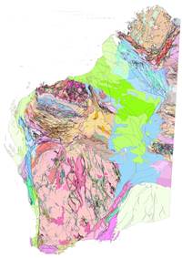
Meanwhile, the geologists and spatial data gurus at WA’s Department of Mining and Petroleum (DMP) have been busy updating their collection of datasets on all the elements of the Western Australian landscape that could be of interest to the resources industries.
The department has been updating spatial information based on hand drawn maps to electronically verified data drawn from compulsory mineral exploration reporting and the government’s co-funded drilling program.
The agency’s assistant director of geoscience, Ian Tyler, told iTnews that the dataset represented the wisdom of over 100 years of government geological surveys.
“But we have improved our understanding more recently,” he said. “The old data contained a lot of imperfections. This is the product of a 130 year journey being brought into the digital era.”
The map can be accessed online by everyone from resources giants to gold prospectors down in Kalgoorlie with their metal detectors, the DMP team said.
The department has also made the raw datasets underpinning each of the map layers available for download so they can be viewed through a company’s own geographic information software (GIS) viewing software.
The state's GeoView mapping service has been built in-house by the DMP spatial team on top of the GeoCortex GIS platform, drawing data out of a number of geological databases, teamed with records of landholdings and land uses.
Roger Hocking, DMP’s chief geoscientist, said WA’s digital push placed it amongst the leaders’ pack when it comes to digitising mineral intelligence.
“Some of the other states are a bit behind in this respect, and are still producing very large printed volumes outlining the geology of particular regions. ‘Hey, nice doorstop’ we tell them," he said.
Other states are also looking towards publishing more of their geological information electronically.
This week Queensland Science and IT Minister Ian Walker launched the ‘Soils Globe’ – a digital map formed from the integration of more than 150 different land surveys conducted by the state government since the 1950s, aimed at helping farmers and miners understand what's in the ground.
It forms part of the ‘Queensland Globe’ - a spatial dataset that has been specially configured for use with Google Earth. The free download allows users to overlay addresses, boundaries, rail networks, land parcels and even areas of flood risk on top of Google's mapping application.

.jpg&h=140&w=231&c=1&s=0)


.png&w=100&c=1&s=0)


 SAP NOW AI Tour ANZ
 Forrester's AI Forum Sydney
 The 2026 iAwards
 Security Exhibition & Conference
.jpg&w=120&c=1&s=0) Integrate 2026
Integrate 2026


_(1).jpg&h=140&w=231&c=1&s=0)


