
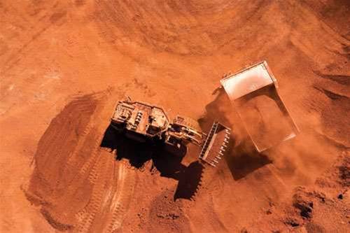
Rio Tinto is increasingly turning to “space-enabled services” to more precisely monitor the impact of its mining operations.
The miner is hoping that Australia’s renewed interest at the federal level in building a domestic space industry will improve the satellite-borne sensors it uses in its line of work.
It said it believed “increased access to space technology [could be] a game changer in the innovation agenda both for mining and for Australia.”
Rio Tinto said it already relies on remote sensing to collect data used in activities such as “exploration, mine and waste monitoring, [and minimising] our footprint on the ground.”
However, it noted there were risks in using “conventional (often low flying) aircraft to acquire data to support exploration and monitoring activities.”
“It is our strong preference to utilise satellite based sensors were possible, particularly where resolution and accuracy are not compromised,” the miner said.
“Rio Tinto is already a consumer of vast amounts of space-enabled services and
applications.
“Having access to position, navigation and timing data is essential for our ongoing productivity.
“In addition, with operations in remote areas, Rio Tinto depends on satellite communication technologies for critical services to support the health and safety of our employees.”
Rio Tinto said it is hoping to see improvements in positioning data, which it relies on in the operation of its automated heavy vehicles at many sites.
It also believed access to higher-resolution data from space-based sensors would be advantageous, particularly as it could help manage competing demands for land use.
“Land use pressures from competing industries and groups, in addition to the resources sector, are expected to increase with time,” it said, adding that better data would help contain the footprint of mines while also ensuring surrounding land remained useful to others.

.jpg&h=140&w=231&c=1&s=0)
.jpg&h=140&w=231&c=1&s=0)


 iTnews State of Data & AI Breakfast
 Forrester's AI Forum Sydney
 The 2026 iAwards
.jpg&w=120&c=1&s=0) Integrate 2026
Integrate 2026
 Security Exhibition & Conference


_(1).jpg&h=140&w=231&c=1&s=0)


