
Two researchers from University of Melbourne have devised a software tool that can predict the boundaries of where landslides happen using big data analytics and applied mathematics.
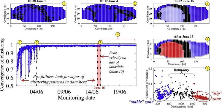
The researchers, professors Antoinette Tordesillas and Robin Batterham took data from radar technologies used by mining companies that measure surface movement on slopes.
Since the radars measure the movement at very high resolution with sub-millimetre precision every six minutes, very large data sets are produced that reveal when landslides are about to happen the researchers said.
“We take this information and turn the numbers into a network that allows us to extract the hidden patterns on motion and how they are changing in space and time,” professor Tordesillas said.
“First, we need to decide which dots, that is locations on the surface of the mountain or mine, are moving.
For each pair of dots, we ask whether their surface movements are similar. If so, the dots are linked. We do this for every pair of dots until we get a network,” she added.
The approach taken by the researchers, using large amounts of data, allowed them to predict where failures resulting in landslides on rock slopes would happen, almost two weeks in advance.
Landslides can be devastating and often occur with little or no warning, causing loss of human life and extensive damage.
With their new software tool, the researchers hope to substantially extend the amount of warning from hours to weeks.
“We can now predict when a rubbish landfill might break in a developing country, when a building will crack or the foundation will move, when a dam could break or a mudslide occur.
This software could really make a difference,” says Professor Batterham.


.jpg&h=140&w=231&c=1&s=0)

.jpg&h=140&w=231&c=1&s=0)

.png&w=100&c=1&s=0)


 SAP NOW AI Tour ANZ
 Forrester's AI Forum Sydney
 The 2026 iAwards
.jpg&w=120&c=1&s=0) Integrate 2026
Integrate 2026
 Security Exhibition & Conference


_(1).jpg&h=140&w=231&c=1&s=0)


