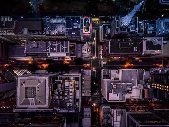
The official public source of land information in NSW, Spatial Services, is turning its 70-year backlog of aerial photography into a 3D digital database for developers, conservationists and historians to understand how the state has changed.
Falling under the Department of Finance, Services and Innovation, the agency is often the go-to place to settle disputes around land boundaries, development proposals and land management.
So as demand for the access to the archive matches the surge in population and development in NSW, the Historical Aerial Photography Enhancement (HAPE, pronounced ‘happy’) digitisation project is expected to ease the pressure Spatial Services’ staff who have to manually sort through over 1 million images dating back to the 1940’s.
Geographic Information System specialist at Spatial Services Jeffrey Hosken told iTnews that a piece of 3D modelling software the agency had used for another project gave them the idea of seeing if it could produce a single digital repository for its historical assets to cut down on the three-day turnaround for imagery requests.
Initially, Hosken wasn’t even sure if it could produce a reliable 2D mosaic - let alone a 3D model akin to what’s available on Google Earth.
“It was a bit of a shot in the dark as to whether this would work or not because you need quite rigid capture requirements for ContextCapture for reality modelling in terms of overlap between frames to get a good model and a good join out of it,” he said
“All this old imagery doesn’t really meet the standards required, but we’ll take a crack and see what we can get out of it.”
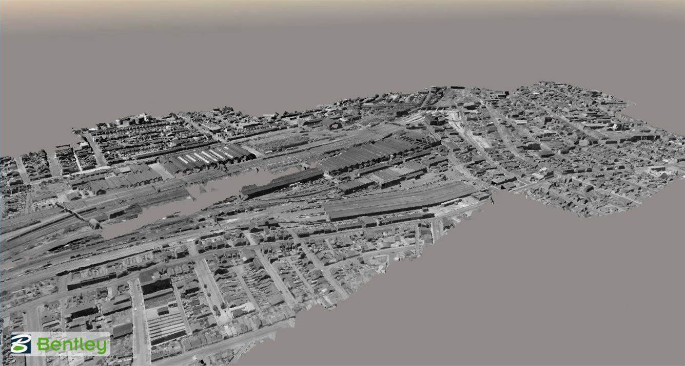
The first HAPE test region was of Brunswick Heads on the state’s north coast, where Spatial Services scanned and entered aerial photos from 1947 into Bentley Systems’ ContextCapture 3D reality modelling software.
“To say we were blown away by the results would be an understatement.
“We matched all these old frames in perfectly, but not only did we get a two-dimensional mosaic out of it which joined all the frames together, we also a got a three-dimensional reality model of what the terrain would’ve been like on the north coast near Brunswick Heads in 1947, which is just invaluable as far as spatial data is concerned.”
The success of the Brunswick Heads trial led to the ambition to digitise and combine the entire $60 million archive of historical aerial images, starting with the ‘Sydney Six’ - the map sheets in highest demand stretching from Lake Macquarie to Wollongong, and out to Penrith.
Beginning in March this year, the HAPE team scanned and entered the aerial images from the 40- to 60-kilometre map sheets, taken every decade since the 1940’s, with some parts of Sydney even having coverage from the 1930’s.
“I’m sure you can imagine from the 1940’s to now there’s been quite a lot of development and change in that area,” Hosken added.
“So if you think of property development cases where someone’s looking at a site development, or it’s new subdivisions or estates or a new industrial area or commercial building, this gives them the ability for them to back through historical imagery and see what was there in the past, what the land has been used for, and if it used to be an industrial site that it might need some remediation done on it now.”
There’s also interest in the new platform from police investigations and legal cases in settling boundary disputes - the 3D historical images can give a clear indication of how cadastral boundaries have been settled or redistributed over time.
Hosken said there’s also interest from the Department of Environment and Heritage to go back and see when and where native vegetation has been cleared across the state, or how regeneration and conservation efforts have succeeded.
After the Sydney Six is completed, the HAPE project will then look out west towards Bathurst, before eventually producing a 3D historical map of the entire state.
The final result is expected to be up to 50 TB in size, which will be stored in Spatial Service’s local data centre.
The first tranche of the HAPE project imagery is slated to be released on Spatial Services’ website by the end of the year, and will be available to the public for free under a creative commons licencing structure.

.jpg&h=140&w=231&c=1&s=0)
.jpg&h=140&w=231&c=1&s=0)

.jpg&h=140&w=231&c=1&s=0)


 iTnews State of Data & AI Breakfast
 Forrester's AI Forum Sydney
 The 2026 iAwards
.jpg&w=120&c=1&s=0) Integrate 2026
Integrate 2026
 Security Exhibition & Conference


_(1).jpg&h=140&w=231&c=1&s=0)