
The federal government will provide $12 million in funding for a two-year project to improve the accuracy of Australia's positioning infrastructure.
Australia currently relies on international technology for positioning, a dependency which was identified by the Space Policy Unit in 2011 as a concern.
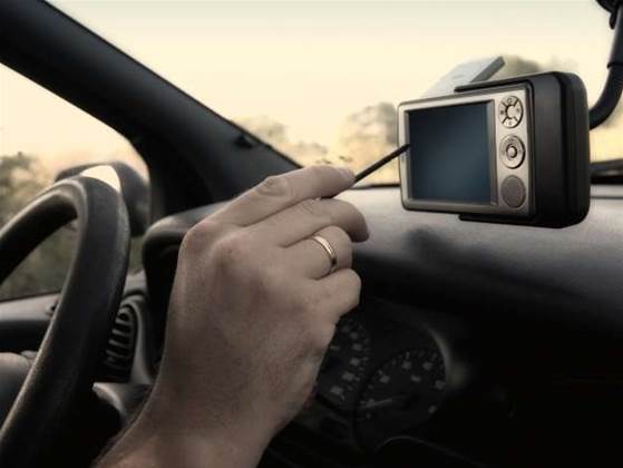
Acting chief executive of Geoscience Australia, James Johnson, said the current positioning systems provide a typical accuracy of between five to ten metres.
The aim of the newly-funded project is to improve positioning accuracy within Australia to less than five centimetres, Johnson said.
Darren Chester, the minister for infrastructure and transport, said the trial would involve testing of a satellite-based augmentation system (SBAS).
SBAS uses both satellites in space and infrastructure on the ground to provide improved accuracy, integrity, and availabiity of signals from systems such as the American global positioning system (GPS).
Geoscience Australia and the Collaborative Research Centre for Spatial Information (CRCSI) will coordinate the testing, which will be undertaken by organisations in different industries such as agriculture, aviation, construction, mining, and land and sea transportation, among others.
The trial will use existing national global navigation satellite systems (GNSS) developed by AuScope, as part of the National Collaborative Research Infrastructure Strategy (NCRIS), Johnson said.
Together with CRCSI, Geoscience Australia will test next-generation SBAS and precise point positioning GNSS technologies, which Johnson said can provide location accuracies of decimetres and five centimetres respectively.
The government believes improved positioning capacity in Australia will have a wide range of applications in traditional industries such as agriculture and mining, as well as growing areas such as driverless vehicles, and could provide up to $73 billion of value by 2030.


.jpg&h=140&w=231&c=1&s=0)
.jpg&h=140&w=231&c=1&s=0)

.png&w=100&c=1&s=0)


 SAP NOW AI Tour ANZ
 Forrester's AI Forum Sydney
 The 2026 iAwards
.jpg&w=120&c=1&s=0) Integrate 2026
Integrate 2026
 Security Exhibition & Conference


_(1).jpg&h=140&w=231&c=1&s=0)


