
This value is now starting to be understood as a way to visually communicate complex data sets in business intelligence and analytics applications, according to Yellowfin CEO, Glen Rabie.
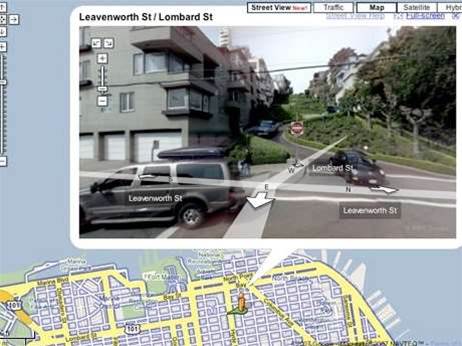
“Up until last year, we’d had no enquiries on location intelligence,” Rabie told iTnews.
“Google Maps has really driven awareness and defined the interface for it. The reality is that people have been trained in [location intelligence] for free.”
Encom’s Chief Architect for GIS, Owen Parfrey, agrees that geospatial awareness is being driven by forces outside of the traditional GIS market.
“Google Earth and Virtual Earth are bringing satellite data and air photography into the home,” said Parfrey.
“It’s not a new topic by any means – we’ve been playing in the space for over 20 years. Our perspective is that it’s interesting to see other non traditional sectors taking interest in having a spatial component.”
BI and performance management vendor, Cognos, claims to be seeing a ‘growing groundswell’ of demand for GIS visualisations, but is cautious of the long-term impacts.
“We’re seeing increased interest but I could put that down to the technology now being more advanced,” said David Merchant, Marketing Manager ANZ for Cognos (now owned by IBM).
“Individual customers have done GIS visualisations over the years, all of a sudden more customers have the tools available to do it.”
The recent release of Microsoft SQL Server 2008 is also expected to drive further awareness of location intelligence for BI.


.jpg&h=140&w=231&c=1&s=0)
.jpg&h=140&w=231&c=1&s=0)

.png&w=100&c=1&s=0)


 iTnews State of Data & AI Breakfast
 Forrester's AI Forum Sydney
 The 2026 iAwards
.jpg&w=120&c=1&s=0) Integrate 2026
Integrate 2026
 Security Exhibition & Conference


_(1).jpg&h=140&w=231&c=1&s=0)


