
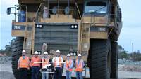
Australia's top miners have opened a new front in their march to automation, flying unmanned aerial vehicles in increasing numbers at remote sites across the country.
An exclusive iTnews investigation reveals the growing acceptance of UAVs as a cost-effective, time-saving and risk-averse alternative to terrestrial survey mapping and other conventional methods of image capture for photogrammetry. Photogrammetry is the practice of determining the geometric properties of objects from photos.
"Ten years ago, I would have had a rat's chance of convincing any mine surveyor to take a UAV on," HELImetrex CEO Ray Gillinder says. "These days it seems to be a lot more acceptable."
The feasibility of UAVs is now being tested for everything from environmental scanning, subsidence monitoring, pit wall mapping, infrastructure assessments and even spare parts transportation to offshore liquefied natural gas (LNG) platforms.
"There's probably a number of uses for UAVs in the mining sector," UAVs Australia commercial director Mark Stevens says.
"The technology itself is actually quite mature. I think people look at it as something almost futuristic but UAVs have been used in the military for over a decade now."
A new generation of aircraft is partly behind the growth in civil uses for UAVs. In particular, the emergence of the Gatewing X100 and several homegrown helicopter-style vehicles (collectively known as vertical take-off and land - VTOL - UAVs) has seen a surge in the number of operators in Australia.
Resources firms have followed suit. Pioneers like Newcrest Mining and Queensland coal miner Ensham Resources are being joined by the likes of BHP Billiton, Rio Tinto and Sibelco in exploring potential use cases for UAV technology at mine sites.
Fire-damaged rig
One of the first case studies for UAVs in the resources sector was the inspection of the fire-damaged West Atlas drill rig and Montara oil platform off the Kimberley coast of Western Australia.
The rig caught fire on 1 November 2009 during attempts to plug an oil spill. The spill is considered to be one of Australia's worst.
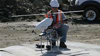
Perth-based Cyber Technology used "a couple" of its CyberQuad minis - usually reserved for "tactical military" operations, according to inventor Joshua Portlock - to inspect the fire-damaged structure about a fortnight later using a standard definition camera payload.
The CyberQuad is a VTOL UAV with four rotors. Its larger Maxi cousin is typically reserved for civil applications.
The UAV was operated from a support vessel moored "a few hundred metres off" the damaged rig, Portlock says.
The UAV pilot "flew the aircraft using virtual-reality goggles to provide real-time reaction to environmental and structural obstacles", according to the company.
"With other monitors, the rig inspectors could make some judgment calls in real time - 'Oh, can you look at that on the left? I'm curious if that's a failed structure'," Portlock says.
"It was quite valuable information for [the Montara rig operators] to get that oblique and close footage".
Portlock says the CyberQuad can be flown "through assets" if the pilot is "competent enough".
"If you do drift into a wall you tend to bounce off and keep going, as long as you don't have too much speed on," he says.
Read on to page two to find out how Ensham Resources, Sibelco and Newcrest have used UAVs.
Stockpile trials
Another major early case study for UAVs in mining is Ensham Resources, a Queensland thermal coal producer that is majority owned by Japanese energy giant Idemitsu.
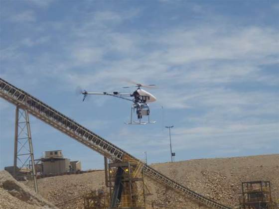
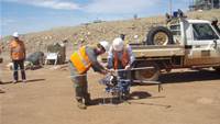
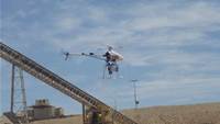
It contracted a trial survey of a coal stockpile and pre-strip dump using a modified Rotomotion VTOL UAV operated by HELImetrex.
Pre-stripping is the process of land clearance in preparation for mining works to begin.
The trial was conducted as part of an undergraduate thesis written by an employee at the time, Kiernan Smithson, who is now a graduate mine surveyor at another large mining firm.
The UAV was flown in late May 2010. Its results were compared to those generated using a terrestrial laser scanner - the most common conventional method for stockpile surveying.
The thesis ultimately concluded that laser scanning was faster and more economical for stockpile surveys. However, the UAV performed well on the pre-strip dump, where "line of sight was poor for laser scanning and the area was very large, requiring many scans and increased travel time [for surveyors] between scans".
In short, UAVs held promise but weren't ready for widespread usage in the mines yet.
HELImetrex's Ray Gillinder - whose machine was used in the Ensham trial - disputes any broad conclusion that laser scanning is better suited to stockpile surveys than a UAV, particularly when it comes to accuracy.
He cites the example of stockpiles where coal is reclaimed from underneath the pile to be fed onto a conveyor and taken to a ship or train for transport.
"That tends to cause a bit of a cone effect inside the middle of the stockpile, and thats something that a terrestrial laser scanner won't see," Gillinder says.
"We've had scenarios where [a customer has] said, 'Our figures don't match up with your figures, why is this?'
"Well, you've got 50,000 cubic metres of coal difference simply because you haven't equated for the cone effect from the underground loading [reclaim] mechanism.
"And therefore the guts of that stockpile is actually hollow. There's nothing there, it's just a volcano-looking thing."
Gold and copper miner Newcrest is also known to be a pioneer of using UAVs for stockpile surveys, however little is publicly known about their usage. A spokeswoman for Newcrest did not respond to requests for comment.
Sibelco's fixed wing design
The alternative to a VTOL aircraft is a fixed-wing design UAV - typified by the Gatewing X100, which counts the Australian arm of Belgian mineral giant Sibelco among its customers.
Sibelco mines an array of minerals that include silica sand, dolomite, feldspar and minerals sands at "about 30 worksites" across Australia.
"Sibelco are trialling a fixed wing UAV for supplementing aerial surveying at some of their sites," surveyor Stephen Talbot tells iTnews.
"It has only been a couple of months and the UAV has been utilised a limited number of times.
"At this stage Sibelco is unable to offer a firm comment on the success or otherwise."
A March 2012 e-newsletter from Australian X100 distributor, Position Partners, notes that "every flight has gone according to plan so far" for Sibelco.
Typical flight time on one battery is between 30 and 40 minutes. "One of our sites covers two square kilometres, and I'd do about three flights, and you'd probably be looking at about one and a half hours of flight time," Talbot says.
Talbot tells iTnews that Sibelco is investigating "potential advantages ...[of] cost and flexibility" when using UAVs.
There is also a safety component, although this is true of using any UAV system.
This is the first part of an extended series by iTnews on the use of unmanned aerial vehicles in mining. Stay tuned tomorrow for the next installment.


_(20).jpg&h=140&w=231&c=1&s=0)
_(23).jpg&h=140&w=231&c=1&s=0)


_(26).jpg&w=100&c=1&s=0)

 iTnews Executive Retreat - Security Leaders Edition


_(1).jpg&h=140&w=231&c=1&s=0)


